
Guabiruba Trails
- Família na Trilha

- Feb 4
- 8 min read
Guabiruba trails: nature, landscapes, and stories hidden among the mountains
Located in the Itajaí Valley, Guabiruba is a city marked by the strong relationship between nature, work, and human occupation. The city developed from agriculture, the extraction of natural resources, and the establishment of small rural communities that shaped the landscape over time. Hills, valleys, rivers, and areas of Atlantic Forest form a diverse territory, where old transportation routes have been transformed into trails used today for leisure, contemplation, and environmental education.

The trails of Guabiruba did not appear by chance. Many of them follow paths used to access farming areas, mineral extraction sites, or strategic observation points in the territory. When walking along these paths, it is possible to see traces of the past integrated into the natural environment, such as abandoned structures, old clearings, and changes in vegetation. Therefore, hiking in Guabiruba is also a way to understand how the city was built over the decades.
In this text, we have gathered some of the main trails in the municipality, highlighting their physical characteristics, level of effort, natural environment, and the historical potential of each one. At the end, we invite you to deepen this view through the digital book “Essa Trilha Tem História – Guabiruba” (This Trail Has History – Guabiruba), which brings together technical descriptions, historical research, and photographic records about these paths.
Why go hiking in Guabiruba?
Guabiruba stands out as a hiking destination because it offers a diversity of landscapes, different levels of difficulty, a strong historical presence, and low levels of mass tourism. In the municipality, you can find trails that lead to waterfalls, viewpoints, and decommissioned mining areas. The waterfall trails offer direct contact with rivers and well-preserved natural environments, the hills provide sweeping views of the region, and the old mines reveal important marks of local economic history. This variety allows you to experience different environments in the same destination.


In addition to diversity, Guabiruba offers trails for different types of visitors, with shorter and more accessible routes suitable for beginners and families, and others that require greater physical fitness and attention to safety. Most of these trails follow old routes used for work, transportation, and land use, directly connecting nature and local history. In addition, the municipality remains outside the main mass tourism circuits, which ensures better-preserved trails, fewer visitors, and a more peaceful, responsible experience that is aligned with the appreciation of natural and cultural heritage.
Where are the trails in Guabiruba?

The trails presented in this guide are spread across different regions of Guabiruba, allowing visitors to explore the municipality in depth, passing through areas with distinct natural and historical characteristics. Three of them are located in the Lageado Alto neighborhood, one in Aymoré, one in São Pedro, and another connecting Lageado Baixo, Planície Alta, and Guabiruba Sul. This distribution reveals how the trails spread across the territory, following ancient land uses, watercourses, and areas of human occupation. Although there are other trails in the municipality, this text focuses on these routes, which represent the environmental and cultural diversity of Guabiruba.
Trail of the Abandoned Mines

Total Distance: 4,6 km
Total elevation gain: 412 meters
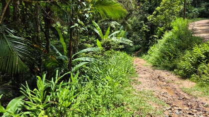
The Abandoned Mines Trail is one of the most emblematic trails in Guabiruba when it comes to the relationship between nature and human activity. Access is via the Lageado Alto neighborhood, initially following a wide road with marks left by four-wheel drive vehicles or motorcycles. This beginning makes the walk easier, but visitors should not be fooled by the demands of the route as a whole, which alternates between uphill and downhill sections.
After about two kilometers, the route leaves the main road and enters a path that is more like a trail, with denser forest and uneven ground. Shortly after this change, there is a shallow water crossing, but this can vary depending on rainfall. From this point on, the old mining structures appear, now deactivated and partially overgrown with vegetation.
The mines do not have any visitor facilities and require extra caution. Flashlights are essential for anyone who wants to explore the interior of these formations, always with caution. These areas help to understand a period when mineral extraction played an important role in the local economy, leaving deep marks on the territory and in the memory of the region.


Lagoa Azul Trail

Total Distance: 5,8 km
Total elevation gain: 310 meters
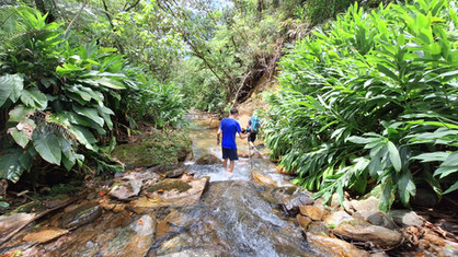
The Lagoa Azul trail stands out in Guabiruba, mainly due to the unique color of the water, which catches the eye at first glance. It is also located in Lageado Alto, with relatively short access, but includes technical sections that require attention. Part of the route runs along the riverbed, which makes it essential to check the weather forecast, and there is also a crossing along the sloping side of a rocky crevice, considered the point of greatest exposure to risk.


The lagoon is located in a specific geological context, which explains its intense color. The surrounding area consists of regenerating Atlantic Forest, with medium-sized trees and a constant presence of birds. It is a good place for longer breaks, observing the landscape, and taking photographs. The main concern should be the considerable depth at some points.
From a historical point of view, Lagoa Azul is located in an area that was also used for mining in the past. Knowing this context broadens the experience and helps to understand that the current landscape is the result of successive transformations.


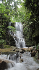
Jerônimo Waterfall Trail

Total Distance: 3,8 km
Total elevation gain: 214 meters
The trail to Jerônimo Waterfall, in the community of Lageado Alto, follows, for most of its length, the old road used to access a sawmill that operated in the region. This initial stretch is wider and allows for a continuous walk, descending towards the river and revealing traces of the logging activity that played an important role in the occupation of the local territory.
In the final stretch, the path leaves the road and follows the course of the river, requiring caution in wet areas and on slippery rocks. The approach to the waterfall is via the riverbed itself, in shallow water, allowing you to walk to the base of the fall.
The highlight of Jerônimo Waterfall is the force of the water, the beauty of the scenery, and the feeling of proximity to the falls. Standing in front of the waterfall, feeling the sound and vibration of the environment, makes the arrival a memorable moment on the trail. In addition to its natural aspect, the site has a direct connection with the history of logging, which influenced the opening of trails and the transformation of the landscape over time.


Morro São José Trail

Total Distance: 2,5 km
Total elevation gain: 266 meters
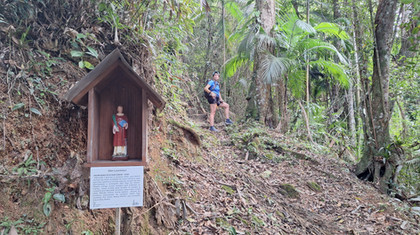
The Morro São José trail begins in the community of Aymoré and its main feature is the gain in altitude. The climb is constant, with steep sections that require physical fitness and a steady pace. In return, the top offers a wide view of the city and the surrounding rural areas, allowing a clear reading of the relief and occupation of the territory.
Along the climb, it is possible to observe religious elements and small statues, which transform the walk into a pilgrimage route. At the top, there is a cross installed in honor of Saint Joseph, placed as a request for protection for the city and its communities. This spiritual aspect reinforces the link between faith, territory, and local identity.
The trail crosses areas of forest and more open stretches, highlighting different stages of land use and regeneration over time.


Guabiruba Sul Waterfall Trail

Total Distance: 1,1 km
Total elevation gain: 41 meters
Guabiruba Sul Waterfall is located in Vereador Érico Vicentini Municipal Park. Access is via the intersection that connects the neighborhoods of Planície Alta, Guabiruba Sul, and Lageado Baixo, an area of preserved forest with easier access compared to other trails in the municipality. The route follows shaded areas, with a constant presence of water, which contributes to cooler temperatures.
The waterfall is formed by several smaller falls, creating different pools and resting areas. The environment is ideal for those seeking direct contact with nature, without major technical challenges.
From a historical point of view, the Guabiruba Sul Waterfall region plays a fundamental role in the development of the municipality and the state. The first hydroelectric plant in Santa Catarina was built on its waters, an important milestone in the process of modernization and the use of electricity in the region. This project shows how Guabiruba's natural resources were used to boost productive activities, influencing the organization of rural neighborhoods and properties over time.


Lorena Waterfall Trail

Total Distance: 0,2 km
Total elevation gain: 7 meters
The Lorena Waterfall trail, located in the São Pedro neighborhood, combines a rural road and a trail through the woods, making access relatively easy. This feature makes it very popular with residents and visitors looking for a shorter walk.
With a short access of about 100 meters, the Lorena Waterfall trail is marked by its ease of arrival and direct integration with the natural environment. In a few minutes' walk, visitors reach the waterfall, which makes the place very popular for quick visits, moments of rest, and immediate contact with nature.


The importance of valuing the historical aspects of trails
The trails of Guabiruba are not just paths through the forest. Many of them bear visible marks of the past, revealing ancient ways of working, traveling, and occupying the land. Roads built for sawmills, access routes to mines, paths used by farmers, and community meeting places remain visible in the landscape, even when vegetation has reclaimed part of these spaces.
Place names, stories passed down through generations, traditional uses, and family memories are directly linked to these paths. Each trail carries stories that help us understand how people lived, worked, and related to the environment over time. To value these elements is to recognize that the landscape is not neutral, but the result of choices, efforts, and adaptations.


In this sense, the trail can be understood as a true living document of local history. Unlike written records or photographs, it allows visitors to walk on the very traces of the past, observe changes in the territory, and perceive the continuity between generations. Strengthening this historical perspective contributes to cultural preservation, responsible tourism, and the construction of a more conscious relationship with the natural and social heritage of Guabiruba.
This trail has history
The digital book “Essa Trilha Tem História – Guabiruba” (This Trail Has History – Guabiruba) is the result of a cultural project aimed at recording, valuing, and disseminating the memory associated with the municipality's trails. The publication brings together historical research, photographs, and narratives that contextualize each route within the process of occupation and transformation of the territory.
The project was funded by the Aldir Blanc Law, through the Catarinense Culture Foundation, in the Catarinense Culture Circuit Public Notice, which guarantees its public, educational, and accessible nature. This institutional support allowed for systematic work to be carried out, including surveys, listening to residents, organizing information, and producing qualified content.

More than just presenting data, the book proposes a way of reading the trails based on local history, valuing knowledge, memories, and experiences that often do not appear in official records. It broadens understanding of the territory and strengthens the relationship between community, heritage, and visitors.
The book is available on this website and serves as an invitation to deepen the experience on the trails of Guabiruba, combining hiking, knowledge, and belonging.

Comments